Reality capture is the process of developing a digital
representation of existing spaces, structures, and infrastructure.
EnTech uses a variety of instruments, including LiDAR technology (also called laser scanning or 3D scanning), to survey buildings and environments. The data from these surveys is used to create precise 3D representations called point clouds, which form the basis of as-built models and 3D BIM models. Our teams have scanned over 1 million square feet of facilities and infrastructure in the New York metropolitan area, across hundreds of projects.
The Right Tool
EnTech’s VDC engineers use best-in-class technology, selecting the most appropriate equipment for each project, from terrestrial laser scanners to drone-mounted cameras.
Established Systems
Our teams are supported by an established framework of proven management systems for control, oversight, and quality, with on-time performance and technical excellence as key factors.
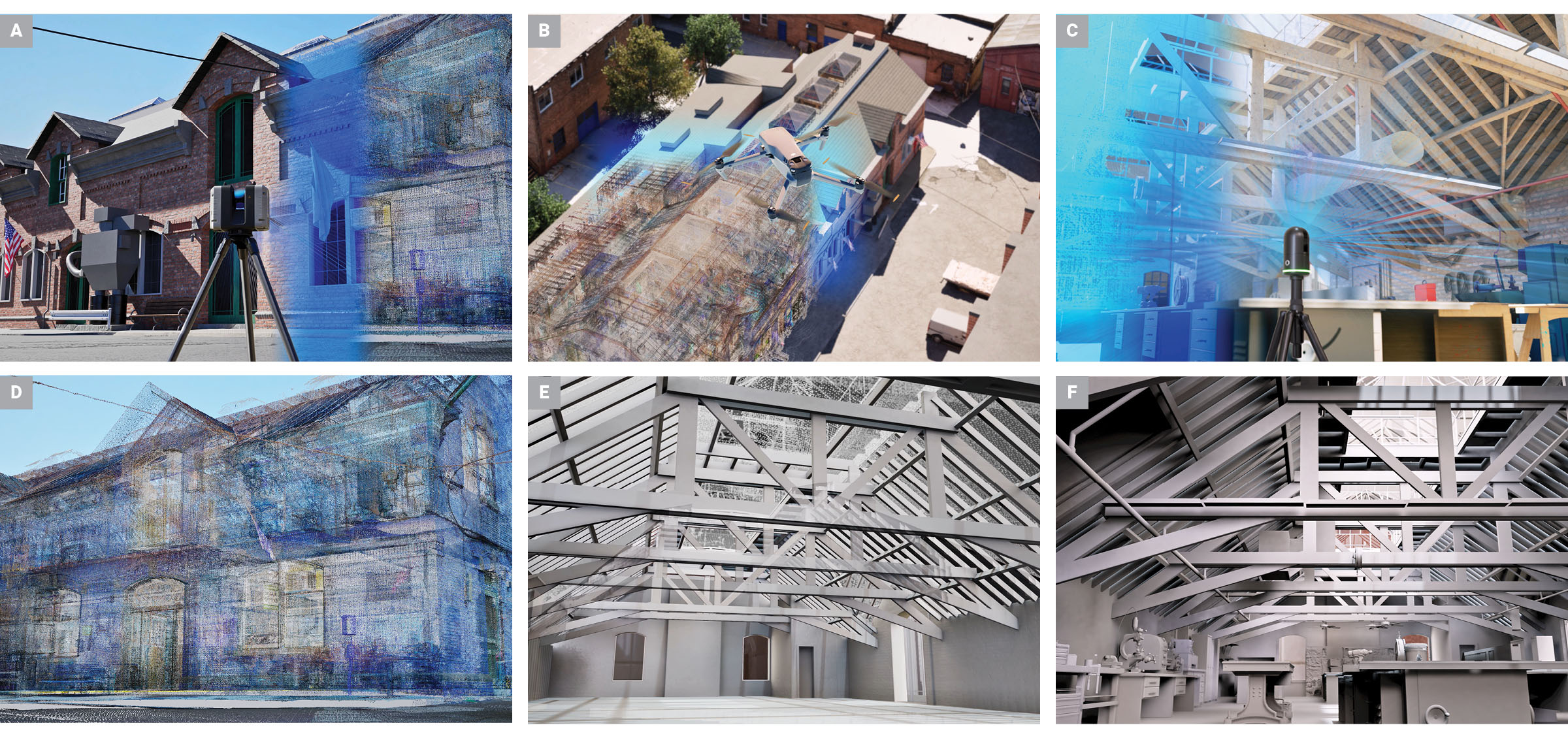
For this project, EnTech first used a LiDAR scanner to capture the exterior of a facility (A) and flew a drone to use aerial photogrammetry to capture the roof components (B). The team then selected a different laser scanner better suited to short distances to scan the building interior (C). Together, these tools generated a point cloud (D), from which the team developed a 3D BIM combining multiple building systems (E–F).
Interior Scanning
Scanning teams select scan points throughout a facility to achieve coverage of interior spaces. By linking 360-degree scans from an appropriate number of points, the team can develop a comprehensive point cloud and subsequent 3D model.
Our field teams use a range of reality capture software tools to assess existing spaces, determine optimal scanning locations, and verify scan completeness.
EnTech’s reality capture teams use multiple scan points to thoroughly capture structures and building systems and generate a comprehensive 3D point cloud.
Lorem ipsum dolor sit amet, consectetur adipiscing elit, sed do eiusmod tempor incididunt ut labore et dolore magna aliqua. Ut enim ad minim veniam, quis nostrud exercitation ullamco laboris nisi ut aliquip ex ea commodo consequat. Duis aute irure dolor in reprehenderit in voluptate velit esse cillum dolore eu fugiat nulla pariatur. Excepteur sint occaecat cupidatat non proident, sunt in culpa qui officia deserunt mollit anim id est laborum.